

BBC News
Lead weather presenter

 PA Media
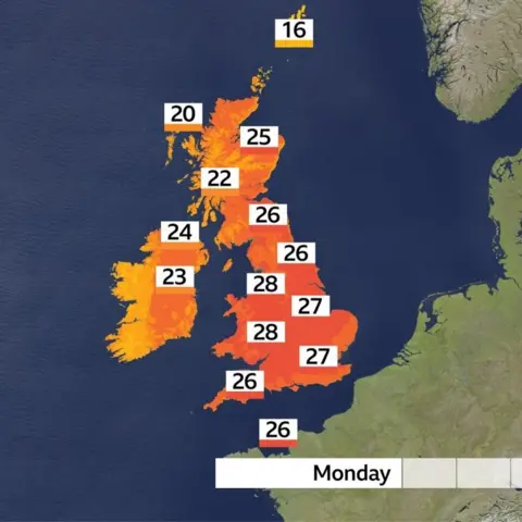
The UK could bask in 30C heat and sunshine this bank holiday Monday, before blustery winds and rain arrive.
The Midlands and the north-west are set to see the highest temperatures, while Wales may be in store for its hottest late August bank holiday on record.
It comes after the Met Office said last week that the summer was already on track to be among the UK’s hottest on record, with four heatwaves declared.
But the heat will be short-lived, as overnight the remnants of Hurricane Erin are set to bring in wet and windy weather – first to Northern Ireland, and then across most of the UK.
Monday’s highest temperatures are most likely to be around the West Midlands, the Welsh border, Cheshire, Merseyside and Greater Manchester.
But further south, the hundreds of thousands of people expected to attend the Notting Hill Carnival in west London can expect plenty of warm weather, with possible highs of 28C.
Parts of eastern Wales could reach 27C – threatening to break its late August bank holiday record of 26.5C, recorded at Crossway in 1991.
Northern Ireland could also break its record of 23.8C, set in Banagher in 1983.
Most of the UK will stay dry and sunny throughout the day, but rain will start arriving in Northern Ireland and Scotland’s Western Isles by late afternoon, along with blustery winds of up to 40mph.
The rest of the week looks much more changeable with showers or longer spells of rain expected, as well as windier, cooler conditions.
This is in part due to the remnants of Hurricane Erin getting closer to the UK, having skirted the Caribbean and east coast of the US this week.
Temperatures in East Anglia and south-east England could still reach 27C on Tuesday, but by Friday the mercury will drop to between 16-19C.
The Met Office expects rain to persist throughout the week – which will be welcome in many parts of the country after a particularly dry summer.
South Farnborough in Hampshire has not seen any measurable rain in August so far, while many other locations across southern England have received less than 1mm of rain this month.

Travel woes for bank holiday
Those hoping to make the most of the warm weather while it lasts may have to grapple with travel delays and cancellations.
A strike on the CrossCountry network could make returning from Leeds festival tricky, while engineering works will mean no LNER trains in or out of London King’s Cross.
Customers are being told not to travel on any CrossCountry routes, aside from those from Birmingham towards Penzance, Paignton, Bournemouth and Guildford.
There will be no CrossCountry trains between Birmingham, Reading and the south coast of England. There will also be no service between Leicester, Cambridge and Stansted Airport.
The RNLI also warned people planning a trip to the coast to use lifeguarded beaches and to beware of rough seas.
Prolonged dry periods throughout this summer have led to a significant shortfall of water in England, with hosepipe bans declared for millions – some of which are set to remain into the winter.
This means the UK is on course for one of its worst harvests on record, according to the Agriculture and Horticulture Development Board, a statutory research organisation.
While linking climate change with specific individual weather events can be difficult, scientists say that climate change is generally making bouts of hot weather longer, more intense and more frequent.
Four summer heatwaves in quick succession after an unusually warm spring suggests climate change is having some effect on 2025’s weather.